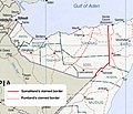
Map_of_somaliland_border_claims.jpg (590 × 504像素,文件大小:118 KB,MIME类型:image/jpeg)
文件历史
点击某个日期/时间查看对应时刻的文件。
| 日期/时间 | 缩略图 | 大小 | 用户 | 备注 | |
|---|---|---|---|---|---|
| 当前 | 2023年10月19日 (四) 17:16 |  | 590 × 504(118 KB) | Maantadhabtiye | https://horseedmedia.net/somali-federal-government-recognizes-new-ssc-khatumo-administration-383891 |
| 2020年6月20日 (六) 18:37 |  | 590 × 504(241 KB) | Kzl55 | Reverted to version as of 12:41, 23 November 2018 (UTC) Map based on Markus Hoehne's work Between Somaliland and Puntland (Contested Borderlands), 2015. | |
| 2020年6月17日 (三) 15:55 |  | 590 × 504(115 KB) | Meelpringthusss | Puntland's proclaimed borders per official government release - http://mediapuntland.org/puntland-map-calls-for-peace-and-respect-for-sacredness-of-human-life-amid-tensions-in-sool-region/ | |
| 2018年11月23日 (五) 12:41 |  | 590 × 504(241 KB) | Kzl55 | Updated based on Markus Hoehne's map in Between Somaliland and Puntland (Contested Borderlands), 2015. | |
| 2007年10月19日 (五) 19:49 |  | 506 × 586(167 KB) | Béka~commonswiki | {{Information |Description=Map of Somaliland border dispute as of August, 2007. Modification of Image:Somalia pol02.jpg fro Wikimedia Commons. en:Category:Maps of Somalia en:Category:PD tag needs updating |Source=Originally from [http://en.wi |
文件用途
全域文件用途
以下其他wiki使用此文件:
- ast.wikipedia.org上的用途
- cs.wikipedia.org上的用途
- en.wikibooks.org上的用途
- eo.wikipedia.org上的用途
- es.wikipedia.org上的用途
- fr.wikipedia.org上的用途
- gl.wikipedia.org上的用途
- it.wikipedia.org上的用途
- ja.wikipedia.org上的用途
- ml.wikipedia.org上的用途
- pt.wikipedia.org上的用途
- ru.wikipedia.org上的用途
- uk.wikipedia.org上的用途


